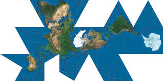
To create a map cartographers transfer an I'mage of the round earth to a flat surface a process called projection. all projection invoke distortion for example and interrupted projection (bottom map) show accurate shapes and relative size of land areas but oceans have gaps other types of projection are cylindrical conic or azimuthal each with certain advantages but all with some distortion. from a called national geographic kids


Subscribe to:
Post Comments (Atom)
-
my teachers going crazy I have no idea why I think as I see a pencil zooming by she got I I no name papers and 20 in here...
-
 Parent company lndustrias la Constancia and it’s brand Pilsner (both Slv) produced a 783.81-kg (1.728-lb) pretzel on 25 oct 2015 at Cifco ...
No comments:
Post a Comment